How Can the Human Race Live in Congruence with the Unavoidable Sea Level Rise?
| ✅ Paper Type: Free Essay | ✅ Subject: Environment |
| ✅ Wordcount: 3202 words | ✅ Published: 23 Sep 2019 |
Population is increasing, land is turning bare and flooding is more constant. How can human race live in congruence with the unavoidable sea level rise?It will occur, either with global warming accelerating its arrival or not (natural cycle of the planet).
WHAT IS CLIMATE CHANGE AND GLOBAL WARMING?
Global warming can be described as the unusual swift increase in Earth’s usual surface temperature over the past century primarily due to greenhouse gases essentially released by individuals burning fossil fuels (Riebeek, 2010). Climate change is a result of global warming and at the same time includes the concept in its definition. To clarify the matter, climate change is a long-term change in the Earth’s predominant weather circumstances (temperature, air pressure, humidity, precipitation, sunshine, cloudiness, and winds) throughout the year, averaged over a series of years (Climate, 2016).
Greenhouse gases (mostly carbon dioxide and methane) are acting as minute heaters for the worldwide temperature (Riebeek, 2010). Naturally, as well as if it were in one’s household, if it is certain to double the quantity of working heaters, the inner temperature will rise. And if one, in its place of double, triples their amount, the temperature will rise even quicker. If such analogy is not sufficient to realize: it is like resting with two blankets instead of one. It will get warmer. Faster. And that is indeed what is happening.
Global temperatures are increasing (Graph 1). From 1906 to 2005, temperatures rose an average of 0.6 to 0.9 degrees Celsius, a quantity that already does not fit current times, as it has nearly amplified these last 50 years. It is anticipated that until the end of this century, temperatures will have climbed 3 to 5 degrees Celsius (orwine, 2014). This is nearby 4 to 7 times faster, when matched to the period amongst the 20th and the 21st century and 20 times faster if one ponders that in former events the earth took about 5.000 years to warm 5 degrees (Riebeek, 2010). The eight warmest years on evidence have all happened since 1998 (UN-Habitat, 2011.) and the hottest 12-month period on evidence was recently registered from June 2015 through May 2016 (Nuccitelli, 2016). Even if Man were to pause greenhouse gas emissions at this moment, the temperatures will remain rising. Consuming the heaters analogy once more, if one turns off a heater after being on, it will shot some time to get back to room temperature. It occurs the same with Earth’s energy: it will take some time until it dissolves. 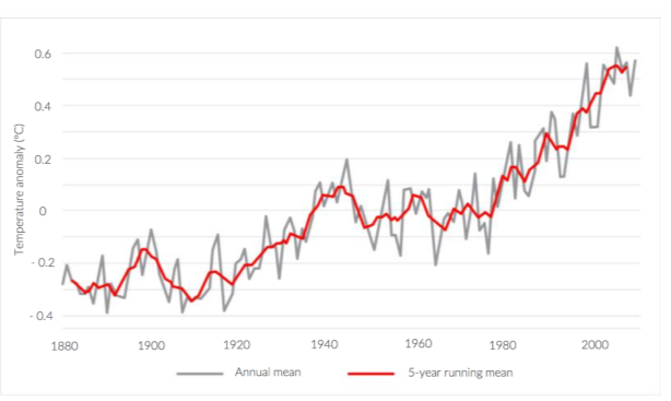
Graph 1 – The global average temperature is rising. As stated, in the last 50 years with a doubled rate.
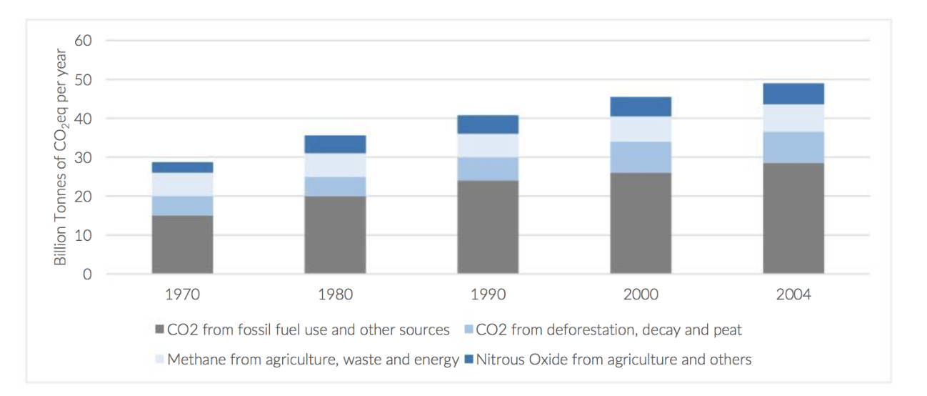
Graph 2 : Global yearly emissions from 1970 to 2004. Adapted from (UN- Habitat, 2011)
The main bases of carbon dioxide, the most significant anthropogenic greenhouse gas, are recognized as coming from the burning of fossil fuels (accounts for 75 per cent of the overall growth of carbon dioxide in the air), deforestation and altering agricultural practices (these two account for the outstanding 25 per cent) .Burning fossil fuels can be associated to transportation, heating and cooling buildings, production of cement and other commodities (UN-Habitat, 2011). In fact, cities, which only take up 2 per cent of the Earth’s land area, are guilty for as much as 75 per cent of the GHGs discharged into the atmosphere. Per capita, developing countries emit lesser levels of GHGs than established ones (UN-Habitat, 2011).
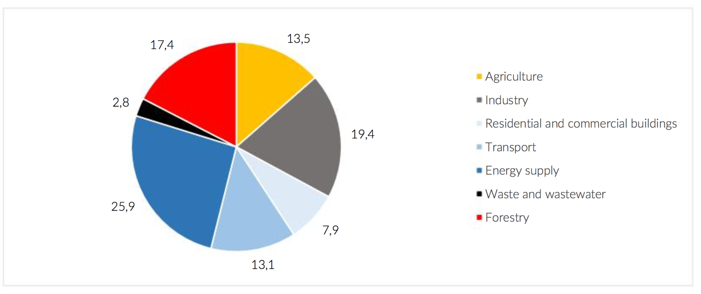
Graph 3- Percentage of different sectors in total anthropogenic GHG emissions, in 2004, in terms of CO2 equivalents. Adapted from: (UN-Habitat, 2011).
WHY IS SEA LEVEL RISING ?
The third most prominent climate change effect and emphasis of this Literature review. Why is sea level rising? Locally, because the land is dipping: according to Steffen Nijhuis and Han Meyer (Meyer & Nijhuis, 2014), the serious deterioration in delta formation and coastal areas, due to the disturbance of sediment flows, is leading to severe land subsidence and deterioration – thus to sea level rise in relation with the level of the land. For instance, New Orleans has already lost 5.000 square kilometres of its Mississippi Delta Area to the sea because of the previous announced reason (Meyer & Nijhuis, 2014). The point that the land was exhausted dry for human settlements to be possible, also aided the land to subside. Some areas of Rotterdam touched an surprizing level of 5 meters below sea, thanks to the drainage of its polders (Bobbink, Meyer,& Nijhuis, 2014). Huge local variances will also be noted liable on the tides, wind and atmospheric pressure patterns, also ocean circulation. Vertical continental movements may also occur upwards in extraordinary cases, resulting in apparent lower sea levels (for instance the Antarctic land masses will rise after being relieved from the pressure of the vast dense ice sheets).
Global warming is accountable for the increasing seas: by heating the ocean and melting the ice on land. Naturally, the ice melt phenomenon just adds bigger measures of water in the already existing oceans . It is accurately pouring water over more water. While heat surges its capacity (as its molecules gain more energy) being accountable for about a third of the present sea-level rise. Since 1900 the worldwide sea level has climbed 20 centimeters (faster than in the past 2.800 years) (DeConto & Pollard, 2016). It is now expanding at eighth of 3.4 millimeters per year – and accelerating (Folger, 2013). As the greatest surface composed by frozen water, Antarctica was computed to hold ice sheets as deep as 3,2 kilometers, comprising up to 90 per cent of the world’s ice. If it were to melt completely, together with Greenland, it could rise sea level by 70 meters (DeConto & Pollard, 2016).
As strained before, even if people discontinue emitting GHGs into the air, the planet will linger to heat and, therefore, the ice will resume to melt and the sea level to rise – Graph 3. In fact, it will not stabilize for millennia (UN-Habitat, 2011).
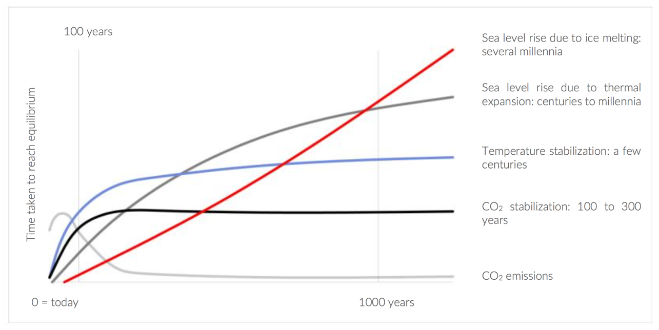
Graph 3 – Relationship between CO2 emissions reduction, temperature stabilization and sea level rise. Adapted from: (UN-Habitat, 2011).
WHAT CAN BE THE INFLUENCE OF CLIMATE CHANGE ?
Despite the fact that this literature review emphases on the powers of sea level rise, it is vital to remark other effects that climate change has been carrying upon urban areas as well. In many cases interventions and actions to fight against these effects do not focus exclusively on one of them, as they are habitually closely related. Flood risk is an alarm of both the heavier precipitations working together with sea level rise, for instance. As much as life-threatening heat events and droughts, evaporating groundwater and increasing vulnerability to saltwater seepage by the sea (one of the consequences of sea level rise) (Meyer & Nijhuis, 2014).
Low elevation coastal zones (less than 10 meters overhead mean sea level) cover over 2 per cent of the earth’s land area but comprise 10 per cent of the world’s population (700 million people) and 13 per cent of the world’s town population. And the trend is for that quantity to keep on increasing (UN-Habitat, 2011).
To gauge the effects of climate change in evident territories it is essential to have in thought not only their exposure to the effects (sea level rise,heat waves, cyclones, heavier rains, droughts , floods etc. the already ones mentioned), but also the urban resilience (responses to dangers and retrieval from disasters), expansion, socio-economic equity, and governance structures as key determinants of adaptive volume and actual adaptation actions.

Heavier rains will have extensive monetary and social allegations through flooding and landslides. Residential and commercial structures, as well as transportation links and infrastructures, are estimated to suffer considerable damage, where flooding is regarded as the priciest and most devastating.
The upsurge in sea level has numerous consequences in land: growth in saltwater seepage inland and in groundwater, rise of flood risk related episodes (this feature is multiplied with the increase in the strength of rainfall and of sultry storms due to global warming) – considered as the priciest and most devastating , augmented coastal erosion and harm of wetlands, clogged drainage and land loss. Other subsidiary impacts are also credible (like the changes in purposes of coastal ecosystems, in the circulation of underneath sediments, dislocation of residents, disruption of transportation and property destruction, etc.) (UN-Habitat, 2011).
As the jeopardy of floods rises through time, so does the potential loss in commercial, residential erections and industrial complexes through the slow start of saltwater seepage. The identical can occur in the transportation link, in road bases and bridge supports. It is also possible that the conduct and eminence of water in cities is disturbed. Cases of such have already been testified in Vietnam. Before, it was jagged out that most urban disasters appear disproportionally in low raise coastal areas. If nothing is fixed to organise settlements in the zone against sealevelrise, 0.2 – 4.6 percent (14 to 322 million people) of the universal population is probable to be drowned annually in 2100 under 25 – 123 centimeters of worldwide mean sea level rise with estimated yearly losses of 0.3 – 9.3 per cent of global gross domestic product (Hinkel, et al., 2014).
United States of America, an upsurge of just 30 cm of mean sea level would erode 15 to 30 meters of the shoreline in New Jersey and Maryland, 30 to 60 m in South Carolina and 60 to 120 m in California. Parts of Louisiana would also vulnerable to land loss. In Mombasa, Kenya, 17 per cent of the land would be vanished (in which hotels and memorials rest with a big a part of the tourism thrift).
Mostly, this continuing effect of evading land will be destructive when bearing in mind other data. It is within the low elevation coastal areas that a prodigious quantity of the world’s fertile land falls in (such as the rice cultures of Vietnam). If worldwide population concentration is expected to be the same in 2100 as was in 2012, another 2.85 million sq km of land will be desirable (69 times the total area of the Netherlands). Studies illustrates that as cities swell, they incline to do so over fertile cropland. If such occurs in this century, a harm of 18 % of fertile cropland may be observed, as 5 billion more people inhabit in cities (attaining an urban population of 8.5 billion. In count to that, requirement for food will radically increase: by 2050 it is assessed that global nutrition supply needs to surge around 70 per cent to 100 per cent compared to existing levels (Graaf, 2012). But agricultural output has been extremely diminishing for numerous decades (United Nations, 2011). Thus, food production will shrink as urban population spreads and low elevation coastal land is gone: it will not be practicable to lodge 5 billion more city dwellers in new domestic urban areas – those should be protected for establishing croplands. What should be thru? Take profit of water bodies as urban expansions?
CITIES AND SETTLEMENTS DEALING WITH THE IMPACTS
The low-lying coastal land of the Netherlands (which is the greatest delta in Europe), for example, has resorted to an methodology known as cohesive spatial planning – a notion in which water management, spatial planning, urban design, engineering and architecture are amalgamated – to confirm sustainable development and the conservation of the delta. They entailed in excavating de-poldering ,floodplains , relocation of dikes, , water storage strengthening dikes, riverbed excavation, lowering breakwater spurs , high water channels, and removal of obstacles.
A typology that has been about for a lengthy time (millennia). The habitable space is built on top of concrete, steel, wooden or bamboo (or other materials, being these the most usual) poles in such a way that there is a upkeep distance amongst the soil and the base of the structure.
The structures are usually discovered constructed over shallow waters or in flood-prone zones, for example in the coast (usually on a beach or in the midmost of the sea – like oil drilling platforms), lakes (similar in Tonle Sap) or nearby rivers and, often, inland in flood-prone region. In each continent, one can trace these structures. In Southeast Asia they are very mutual between fishermen villages.
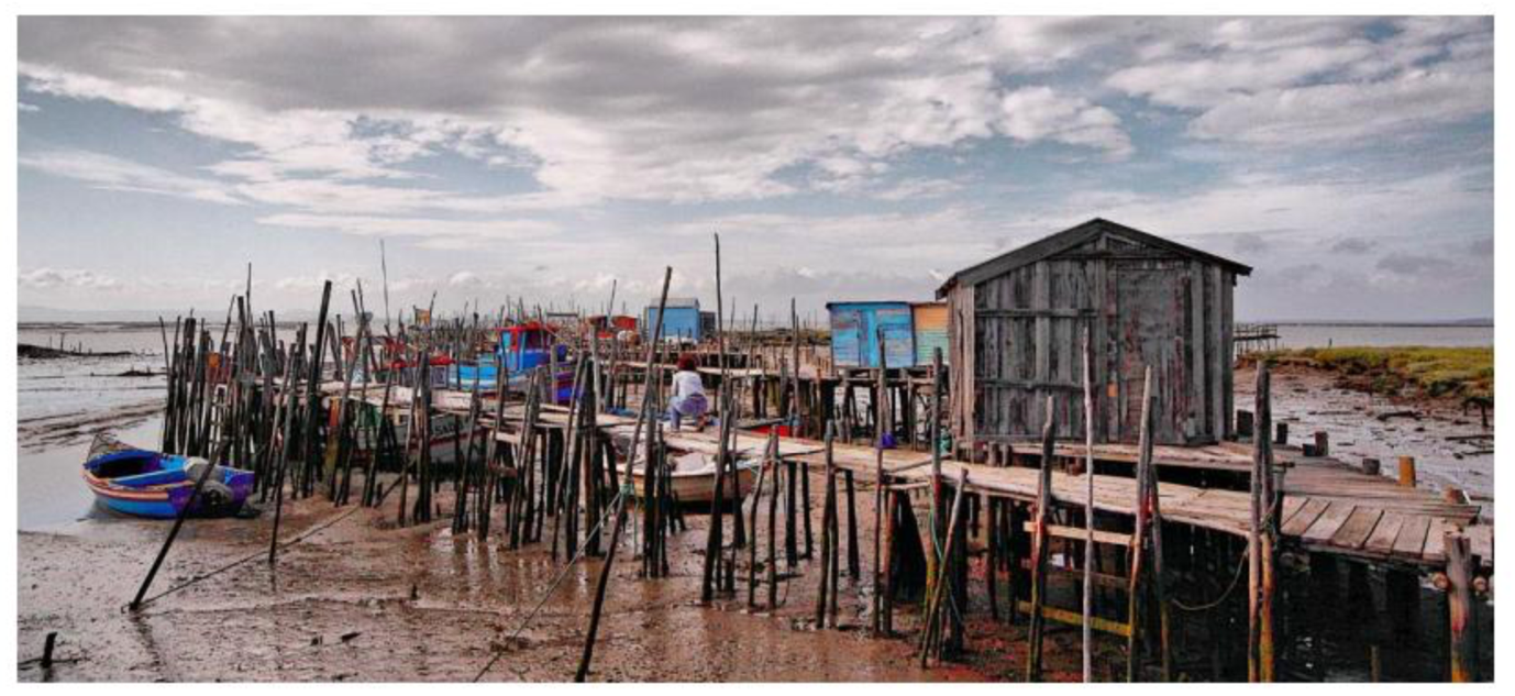
Figure 1 – Carrascueira, in Portugal, constitutes a stilt pier built by local fishermen. Source: (SetubalTV, 2014).
RESPONSE TO WATER LEVEL RISE
In Euro cities, there have been people residing in boats since the 17th century. In structural terms, the body of a houseboat is built up from steel or wood (like those of boats). Since its common materials are lightweight and its measurement small, the construction leans to be very vulnerable to the consequences of robust winds and currents since of its higher center of mass. It may effortlessly tip over if cargo on board is not proportionally distributed. Thus, it is more regular to find houseboats in stiller waters such as in lakes, canals, or rivers. In open sea, as well on the coast, they can turn over with ease when aimed by storms, waves or strong winds.
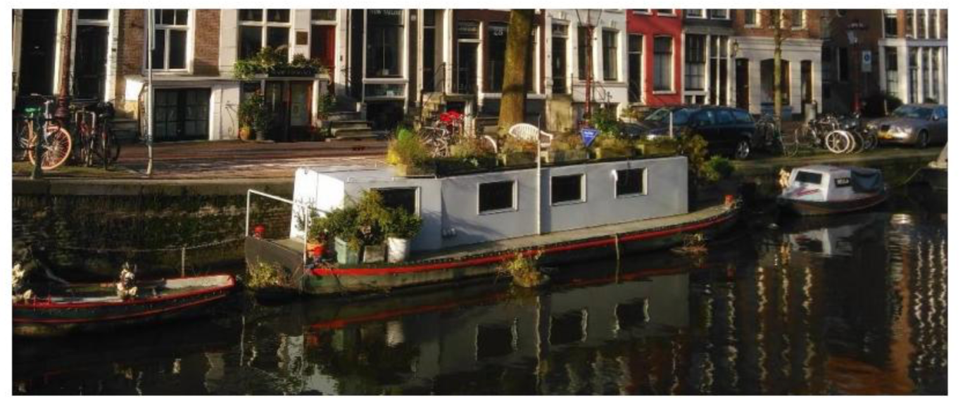
Figure 2 – A houseboat moored into one of Amsterdam’s water canals.
FLOATING STRUCTURES
MAKOKO FLOATING SCHOOL (SALT WATER LAGOON TYPOLOGY)
Makoko Floating School (MFS) was a architype floating structure which was engrossed in to address the needs of an progressively urbanized Africa in the context of climate change. The community lives fundamentally from sawing and fishing businesses and uses canoes as transportation, carrying out its responsibilities amongst stilt structures which were pigeon-holed illegal in 2012 by the government (Fairs, 2016).
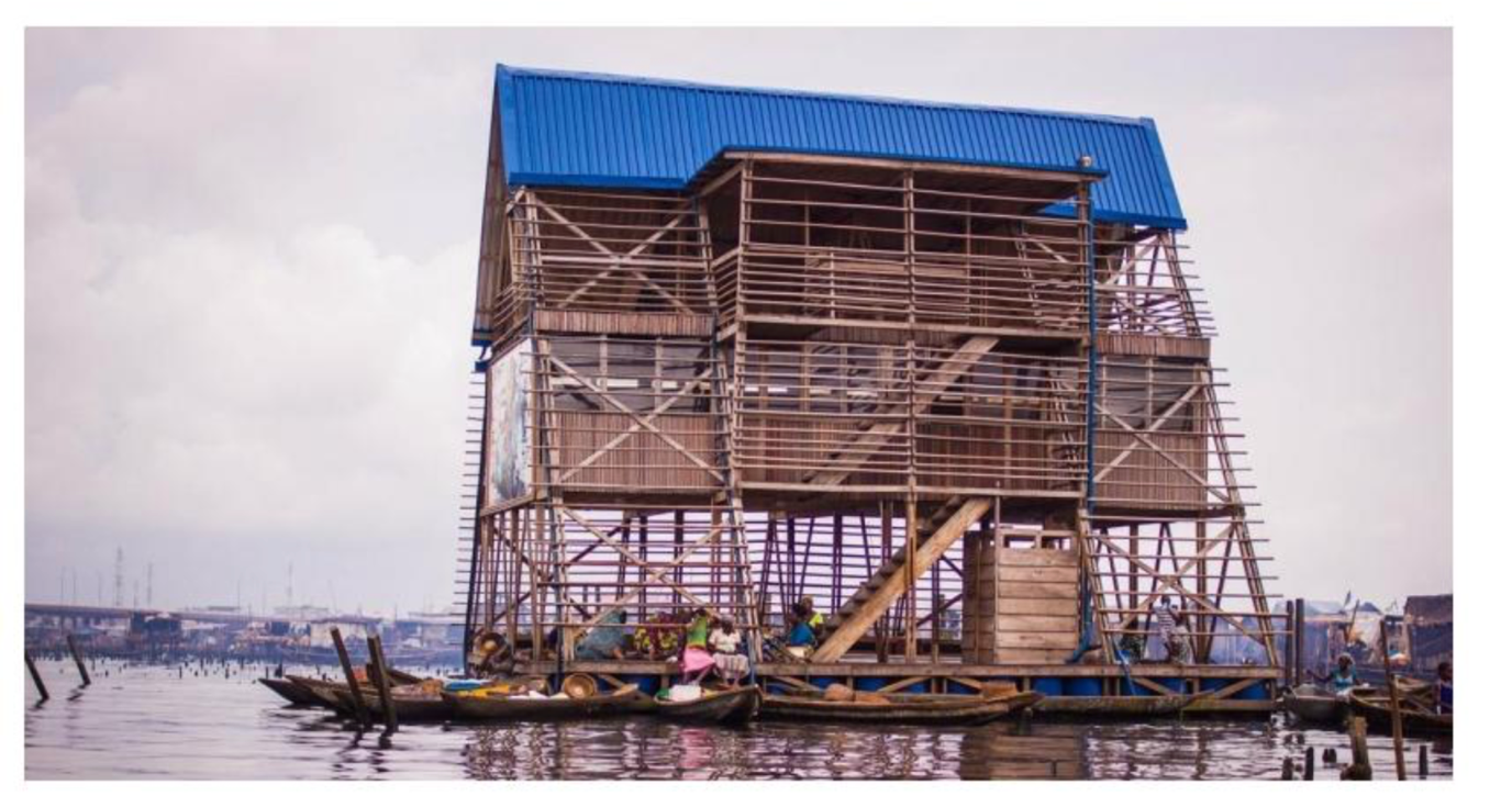
This school revealed great signs of degradation, as it was prone to grave flooding that regularly obstructed the children’s access to education. Due to the surge in rainfall and sea level rise, which openly affect the lagoon’s water level, Makoko’s structures have been suffering consistent flooding.
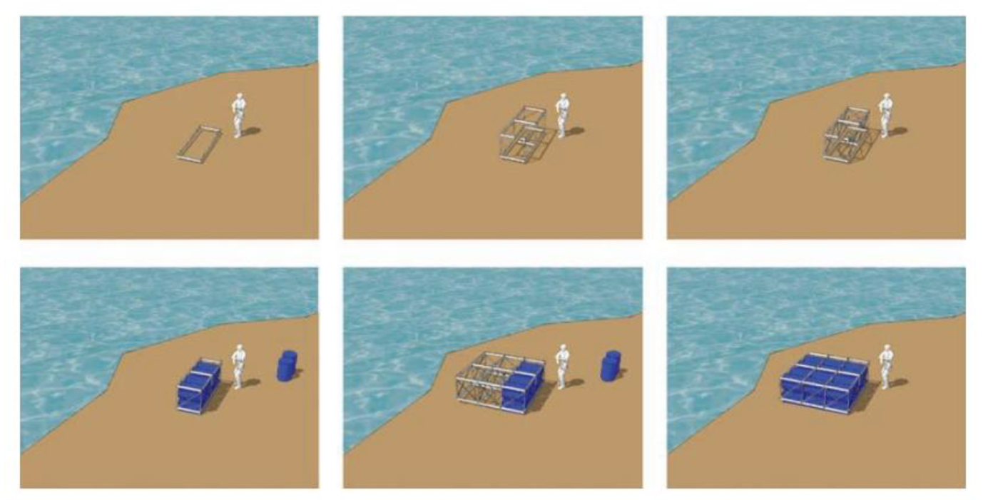
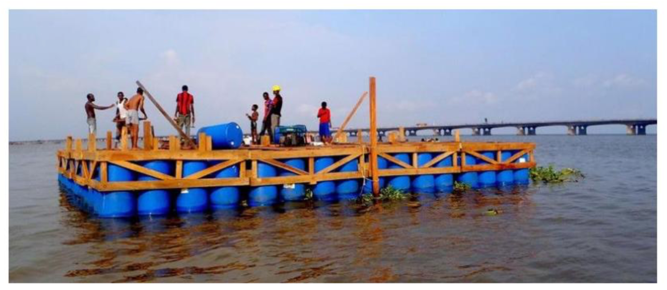
Figure 3 – First, the frame is built inland and filled with barrels. Then it is put on water to join the rest of the components in forming the 10 x10-meter platform. The disposition of the barrels turned out to be vertical, instead of horizontal as in the image, and the wooden frame turned out to be simpler. Source: (NLE, 2012).
The ultimate structure turned out to be a 10 by 10 meter, three floored much higher than the average single floored structures of the community (Fairs, 2016)) and 10-meter tall A-frame assembly. The frame held an bounded rectangular container of about 55 square meters whose ceiling endowed the upper and last floor, a semi-enclosed rooftop, of the similar size (NLE, 2012). Construction commenced in September 2012 for the analysis of the foundation which was founded by 16 wooden modules assembled inland, each with 16 empty recycled plastic barrels (totalizing 256) (NLE, 2016).
AMPHIBIOUS STRUCTURES
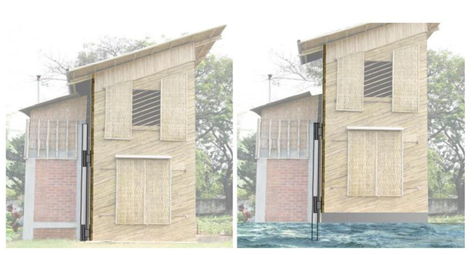
THE LIFT HOUSE (FLOOD RELIEF AREA) The LIFT (low revenue flood-proof technology) house pilot project was planned and constructed in Dhaka, Bangladesh, by Prithula Prosun, a student of the University of Waterloo, in Canada. It is sustainable, designed for low income societies in flood proof areas. As it will be seen additional in detail ahead, millions of people are banished by the severe floods in the country due to sea level rise, brimming of the rivers, insufficient drainage and hefty monsoon rains.
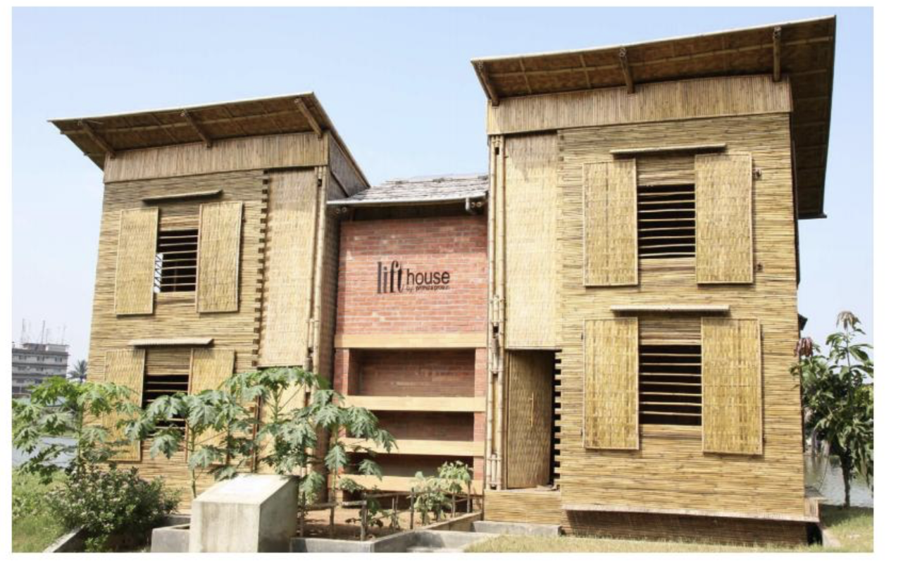
Figure 4 – The LIFT house
As with the Makoko Floating School, the LIFT House was emerged after widespread research on local features and tangled the local community of builders, artisans and people in its making. Its design constitutes a dominant substantial core with all the facilities which are communal (access to water and toilets) and to which two lateral frivolous bamboo structures with floating capability are attached. Each of them is designed to accommodate a family of five members. Both have different foundational systems: one has 8000 water bottles inside a bamboo-frame structure (Good, 2011) – Figure 4, while the other has a ferro-cement body based on the Dutch amphibious models.
Three kinds of bamboo were used: Boruck (almost 8 centimeters thick) for structural mechanisms and pegs, as it is the sturdiest, Jawa for peripheral wall finishes and the two floor layers, as it raises high and straight and Mulli, the softest, divided into thin layers in order to weave into mats used in walls, windows and doors (Prosun, 2011).
CONCLUSION
In this literature review, the emphasis on architecture as a probable solution for climate change induced effects, with special prevalence on sea level rise and it is related to higher flood risks has been presented through a study and a design intervention.
Cities and human settlements in the low elevation coastal areas will have to increase their water catchment surfaces, to re-evaluate their rules in order to guard low-lying lands, mangroves, croplands and to end people from inhabiting in these and other harmful areas, further aggravating soil subsidence and consequently revealing the cities to higher flood risks. At the same time, GHG emissions need to be minimized.
Another in determination, which was not mentioned in the writings, but could establish a framework for upcoming research, is how much the plastic drums could be filled with water, or another liquid, to condense the foundation stronger (more stable), providing more space for rainwater storage and, at the same time, confirming floating capacity.
POSITION STATEMENT.
The low elevation coastal bands of the least industrialised countries, as it has been seen, are facing the highest vulnerabilities. As an Interior Designers/Architects we have the role of scheming sustainable, and flood resilient structures for the fast-paced urban evolution seen in the megacities of the area, which often inhabit the low-lying lands, with no regulation whatsoever. If such is certain to remain happening, the houses the people are to build, or that are to be constructed for them, should be flood resilient and should offer the basic needs, delivering the means for its inhabitants to ultimately move out of the low-lying land when they have sufficient money to do so (because they do not spend on the renovation of their houses after each flood event).
Every person should be cautioned for their own character towards the environment. Just speak out!
BIBLIOGRAPHY
- Anderson, H. C. (2014). Amphibious Architecture. Living With a Rising Bay. San Luis Obispo: Faculty of California Polytechnic State University.
- Archdaily. (2013, March 14). Makoko Floating School / NLE Architects. Retrieved from Archdaily: http://www.archdaily.com/344047/makoko-floating-school-nle-architects
- Bobbink, I., Meyer, H., & Nijhuis, S. (2014). Delta Urbanism. The Netherlands. Chicago, IL: American Planning Association.
- DeConto, M., & Pollard, D. (2016, April 1). Contribution of Antarctica to Past and Future Sea-Level Rise. Nature, 531, 591-596. Retrieved from National Geographic: http://www.nature.com/articles/nature17145.epdf?referrer_access_token=WNxvUvO2KyG I h F6 -Ph9iXNRgN0jAjWel9jnR3ZoTvOM -pvJMg7VLI N Ra2mn TN syX9SwH mNgk2ZS-ImxVn M USWKU IF M 1 Hm 1 Kp8NXJ -GU h3UT3515fu5v18oKa6bvqyzr74- WCc39sUjO5jMzdxq pKrA4nr0Erle_kBJ u lcd RIN NTUWSD8tm 16Y04v
- Graaf, R. (2012). Adaptive Urban Development. Rotterdam: Rotterdam University Press.
- Hinkel, J., Lincke, D., Vafeidis, T. A., Perrette, M., Nicholls, J. R., Tol, R. S., … Levermann, A. (2014, February 3). Coastal Flood Damage and Adaptation Costs Under 21st Century Sea Level Rise. Retrieved from The National Center for Biotechnology Information: https://www.ncbi.nlm.nih.gov/pmc/articles/PMC3948227/
- Nuccitelli, D. (2016, July 11). We Just Broke the Record for Hottest Year, Nine Straight Times. Retrieved from The Guardian: https://www.theguardian.com/environment/climate-consensus-97-per-cent/2016/jul/11/welust-broke-the-record-for-hottest-year-9-straight-times
- NLE. (2012). Makoko Floating School Research Report – Apr/ 2012 Amsterdam: NLE; Heinrich Boll Stiftung. NLE. (2016). Makoko Floating School. Retrieved from NLE: http://www.nleworks.com/ Norwine, J. (2014). A World After Climate Change and Culture-Shift. Oologah: Springer.
- Riebeek, H. (2010, June 3). Global Warming. Retrieved from Earth Observatory. Where Everyday is Earth Day: http://earthobservatory.nasa.gov/Features/GlobalWarming/
- UN-Habitat. (2007). Global Report on Humam Settlements 2007 Retrieved from UN-Habitat: http://unhabitat.org/wp-content/uploads/2008/07/5200_6296_dis-9.pdf UN-Habitat. (2011). Cities and Climate Change. Global Report on Human Settlements. Malta: Gutenberg Press. UN-Habitat. (2012).
Cite This Work
To export a reference to this article please select a referencing stye below:
Related Services
View all


DMCA / Removal Request
If you are the original writer of this essay and no longer wish to have your work published on UKEssays.com then please click the following link to email our support team:
Request essay removal